|
El Hatillo Household Dataset |
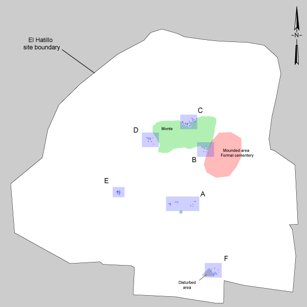
Click on the map below for an
enlarged image of each area
Stratigraphy
Each stratigraphic layers is referred to as a zone. Each area of excavation has a unique set of zones that is, separate stratigraphy. Within each area of excavations, the zones are labeled numerically beginning with the lowest stratum/zone, typically sterile soil or bedrock, as Zone 1, or simply Z1. In many cases, a single zone varied in its appearance, make-up, and artifact content. Such instances usually provided indications of differences in the way particular areas were used. For example, areas where structural remains had collapsed over former floors were distinct from areas where debris had accumulated more naturally over extramural surfaces; the former were often darker due to higher ash and organic content, and often contained more artifacts, particularly lithics, and daub among the remains. In such cases, a letter is added to the zones label (Z2A, Z2B, etc.), creating "sub-zones" that distinguish between the different characteristics of otherwise stratigraphically equivalent layers of sediment.
Field drawings of certain profiles that depict the stratigraphic zones have been digitized and can be seen by clicking on Areas A-F in the map to the right. These drawings provide necessary illustrations of the sometimes thick and convoluted stratigraphic descriptions. In order to enhance the utility of these drawings for the reader, they have been simplified. That is, in some cases drawings from walls that are not contiguous, have been linked as if they are contiguous in order to provide a larger image and fuller sense of the stratigraphy. To be sure, this has not misrepresented any information or altered the way the zones appeared naturally indeed, it seemed to confirm to correct identification of the natural strata in each area because drawings from non-contiguous walls could be joined so readily. Further, details of the stratigraphy such as individual artifact concentrations or root disturbances have been eliminated from all but a few profile drawings in order to enhance to viewers ability to recognize individual zones and sub-zones. Finally, not all features described in the text for a given zone appear in the profile drawings simply because not all features, indeed comparatively few, appeared in profile. Those that appeared in profile during excavation are included in the digitized drawings provided here and labeled in correspondence with their description in the text.