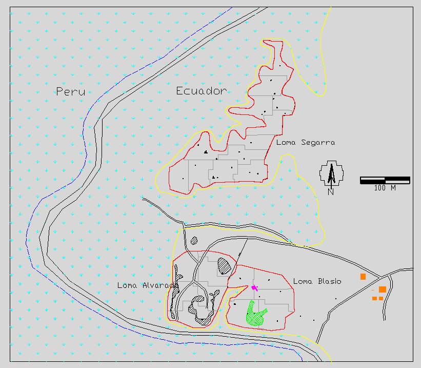
Site Map
The location of each excavation unit as well as additional features are provided as an AutoCAD (Release 12) DXF file. The file is named MAP.DXF. The units of the drawing are in meters and correspond to the actual UTM coordinates (WGS 84 datum). The layers in this drawing, their colors, and the information contained on each are as follows:
- 50M_X_50M GRID (gray): Open Autocad polylines delimiting the extent of the each 2500 m² block from which one 1 m x 1 m unit was randomly chosen.
- DISTURBED SOIL (black/white): Closed Autocad polylines delimiting backdirt piles from the destruction of Loma Segarra.
- EDGE_OF_HILL (yellow): Open Autocad polyline delimiting the extent of the hill tops.
- FLOODPLAIN (cyan): Hatched area delimiting the floodplain of the Zarumilla River.
- LEGEND (black/white): This layer contains the scale and north arrow.
- LIMITE_INTERNACIONAL (blue): Open Autocad polyline identifying the location of the international border between Ecuador and Peru.
- MIDDENS (black/white): Autocad circles marking the locations of surface collections from visible midden. The unit label is a text string with its insertion point within the unit's boundaries.
- MILITARY_FEATURES (purple): Modern military features.
- MODERN_STRUCTURE (orange): Modern houses.
- ROADS (black/white): Dirt roads.
- SITE_BOUNDARY (red): Open Autocad polyline delimiting the site boundaries.
- TOLA (green): Open Autocad polylines delimiting the edges of the tola.
- UNITS_EXCAVATED (black/white): Closed Autocad polylines delimiting the locations and extent of excavation units. The unit label is a text string with its insertion point within the unit's boundaries.
Return to the Table
of Contents