|
Quijos Settlement Dataset |
Comparative |
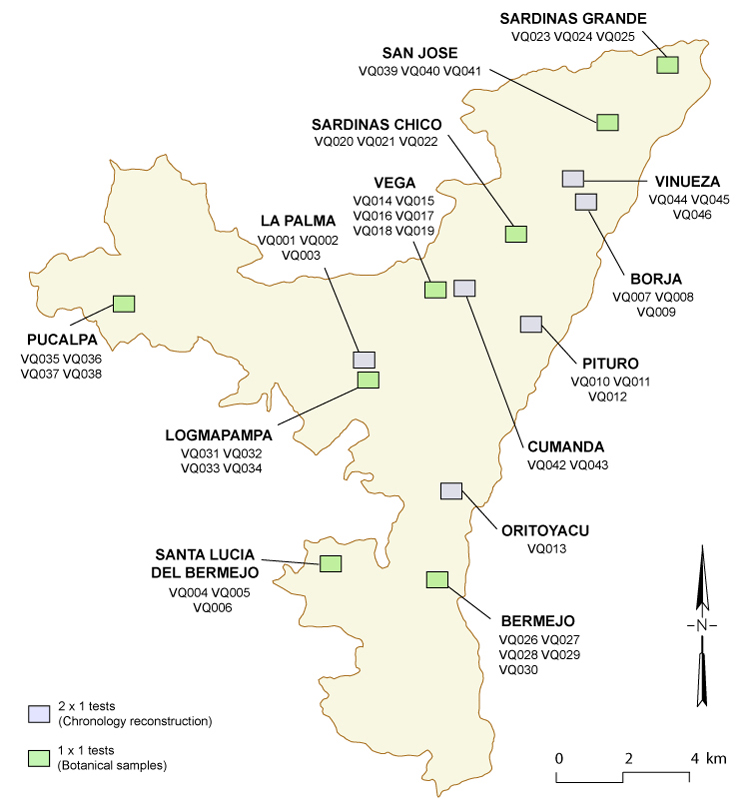
This section presents detailed information regarding the location and stratigraphy of the fifteen 2x1 units excavated to reconstruct the local ceramic chronology, as well as for the additional thirty-one 1x1 units excavated to collect botanical samples, which further provided corroborating evidence about the chronological placement of different ceramic types.
Choosing sites for excavation of 2x1 m tests followed observations of the survey materials after this had yielded a reasonable number of collections with which I started to sort out different ceramic types. I chose sites based on collections that appeared to have only one ceramic type and collections that appeared to have more than one. As the materials of the initial tests were analyzed and more collections were available from the survey, I continued to choose more sites, every time narrowing down the specific questions that I wanted to answer with the excavation of each set of tests. This process of narrowing down the questions became more productive as I gained more familiarity with the ceramic materials, and felt more comfortable sorting them out in groups that appeared to be relevant in terms of chronology.
Apart from observations about the ceramic materials of survey collections, observations of the landscape were also important in deciding where to excavate the 2x1 stratigraphic tests. This involved visiting sites that could potentially answer the questions I had in mind (based on survey collections), and choosing one or two that appeared to present acceptable conditions for stratigraphic excavations. Sites on top of hills or in flat areas were less likely to have been subject to depositional processes that would complicate the interpretation of stratigraphic sequences, making them preferable in the selection process. This approach to choosing sites for chronological reconstruction differs from what is more common in the archaeology of Ecuador and elsewhere, in which the tendency is to choose the largest site, the tallest mound, the deepest deposit, or the one with more ceramics and invest a substantial amount of time and effort in one large excavation. The idea is that this single site will provide the best answers to chronological reconstruction. This has not always been the case, yet the excavation of small tests in "unattractive" sites is still looked upon with suspicion arising from the perception that more "attractive" sites will inevitably produce "more" or "better" material. The fact is that "unattractive" sites can actually yield valuable information for chronological reconstruction. Very often small sites without surface features have the advantage of being less disturbed since they do not attract the attention of looters, and because they generally do not yield overwhelming quantities of material, they can be analyzed within much less than ones lifetime, making results available more quickly to the scholarly community. Reducing the size of excavations also contributes to this end. The efficiency of this approach allows extending observations to many sites (even if "unattractive" ones), which strengthens the interpretation of each one individually. The rationale for this approach is persuasively and extensively presented by Drennan (1993), and this is the one that guided the design of my plan for chronological reconstruction.
Stratigraphic tests were oriented North-South (long axis), and the vegetation cover was removed with shovels. Once the excavation of soil started, shovel and trowel were used alternately and the soil removed was placed in buckets to be examined manually or passed through a 15 mm screen. Excavation layers were defined on the basis of changes in the characteristics of soils, trying to follow the particular stratigraphy in each case, but the generally wet condition of sediments made this goal frequently unattainable. Arbitrary levels of 10 cm were employed when soil changes were not perceived; this was repeated until culturally sterile soil was reached. Levels were given numbers starting with 1 for uppermost. Often we excavated one more 5 or 10 cm level to ensure that we had exhausted the possibility of finding more cultural materials. For each stratigraphic test we filled out a form that included observations about the site and its surrounding landscape and vegetation, and details of the excavation. For each level we filled out level number and depth, took notes about the soil and features if these were present, materials collected and number of bags of each type, method of recovering materials from the soil removed (screening, manual inspection), whether samples for radiocarbon dating had been collected, and references to photographs if these were taken. The bags of materials collected in each excavated level were marked with the name of the site, excavation number, level, depth, and type of material collected. Drawings of profiles were made on graph paper after each excavation was finished, as well as and sketches or other drawings (of features, for example).
The interactive map below provides detailed information about the location, stratigraphy, and changes in ceramic proportions within each 2x1 unit.
In addition, 31 test pits were excavated to collect botanical samples. The ceramic materials within these test pits also offered corroborating information regarding the chronological placement of each ceramic type. More complete details about the rationale used in the placement of the 1x1 m test pits is provided in Chapter 6 of the published volume from which this electronic document is derived.
The interactive map below provides information about the location, stratigraphy, and changes in ceramic proportions within each 1x1 unit.
click on the map for detailed information about each excavation unit
Return to "Ceramic Chronology and Stratigraphic Testing" Main Page